
 NASA's Mars Reconnaissance Orbiter has captured more than 13,000 images of the red planet's surface. And now, the space agency wants your input on what images to acquire next.
The High Resolution Imaging Science Experiment (HiRISE) camera is currently the most powerful camera on any NASA spacecraft. The images it has collected are truly amazing. They highlight how similar the Martian landscape is to Earth in some ways, as well as how otherworldly other parts of Mars can seem.
We've collected just a few of the oddest and most beautiful shots. If they inspire you to want to pick the next strange location for HiRISE to focus on, NASA has created a website where you can scan the planet's surface and make suggestions.
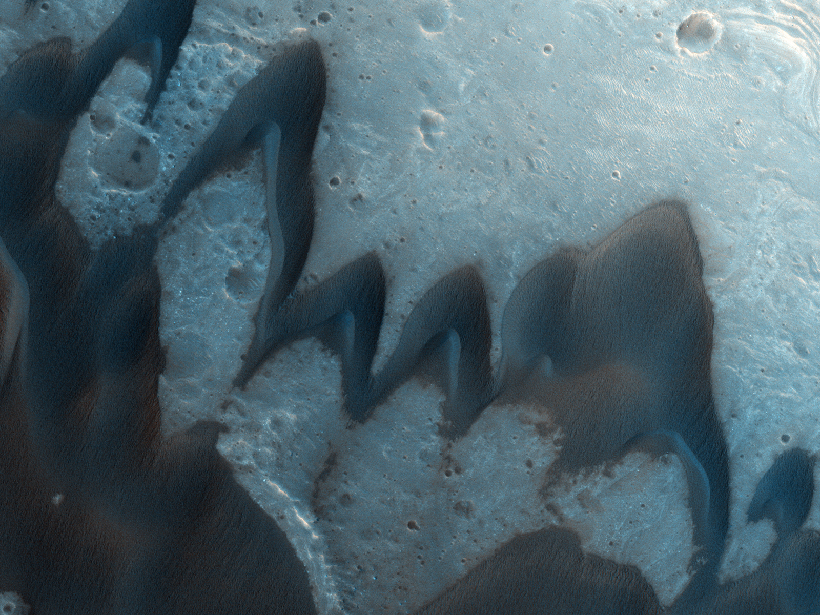
The image above shows a dune field on the floor of a crater made by an asteroid impact.
Click on any image in this gallery for a higher-resolution version.
Image: NASA/JPL/University of Arizona
 This image of layered deposits on a plateau in the Valles Marineris region of Mars was taken in 2007 by the High Resolution Imaging Science Experiment (HiRISE) camera on NASA's Mars Reconnaissance Orbiter. The image shows about three-fourths of a mile across. Scientists think the layers contain opaline silica and iron sulfates formed through alteration by acidic water.
Image: NASA/JPL-Caltech/University of Arizona

This image is of the carbon dioxide ice cap at the south pole of Mars. The pattern is formed by the ice vaporizing. Scientists think that as the ice cap melts from the bottom up, the carbon dioxide turns directly into gas. It flows beneath the ice to openings, eroding the ground below into a spiderlike network of troughs. The flowing gas also carries dust that escapes with it and settles into fan-shaped deposits on top of the ice.
This image was taken in February 2009 by the High Resolution Imaging Science Experiment (HiRISE) camera on NASA's Mars Reconnaissance Orbiter. It covers an area around .6 miles across.
Image: NASA/JPL-Caltech/University of Arizona
 This image shows an area within Proctor Crater that has both dunes and ripples. The smaller, brighter ridges are ripples made of very fine sand. The larger, darker forms are dunes made of dust from dark volcanic rocks. This image was taken by the High Resolution Imaging Science Experiment (HiRISE) camera on NASA's Mars Reconnaissance Orbiter in February 2009.
Image: NASA/JPL-Caltech/University of Arizona
 The angle of this image of Victoria Crater reveals layering at the top of the crater walls. The pattern on the floor of the crater is made of sand dunes. Tracks from NASA's Opportunity rover can be seen on the left side of the crater. This image was taken in July 2009 by the High Resolution Imaging Science Experiment (HiRISE) camera on NASA's Mars Reconnaissance Orbiter.
Image: NASA/JPL-Caltech/University of Arizona
 This false-color image looks like it could be of the desert southwest in North America. These gully channels running from a cliff area near the crater rim show typical shapes made by water-carved streams on Earth. The image was taken by the High Resolution Imaging Science Experiment (HiRISE) camera on the Mars Reconnaissance Orbiter.
Image: NASA/JPL/University of Arizona
 Above, Scientists have found evidence of iron-bearing sulfates and clay minerals in the exposed areas of this region of the Noctis Labyrinthus formation. A dune field covers some of the ground.
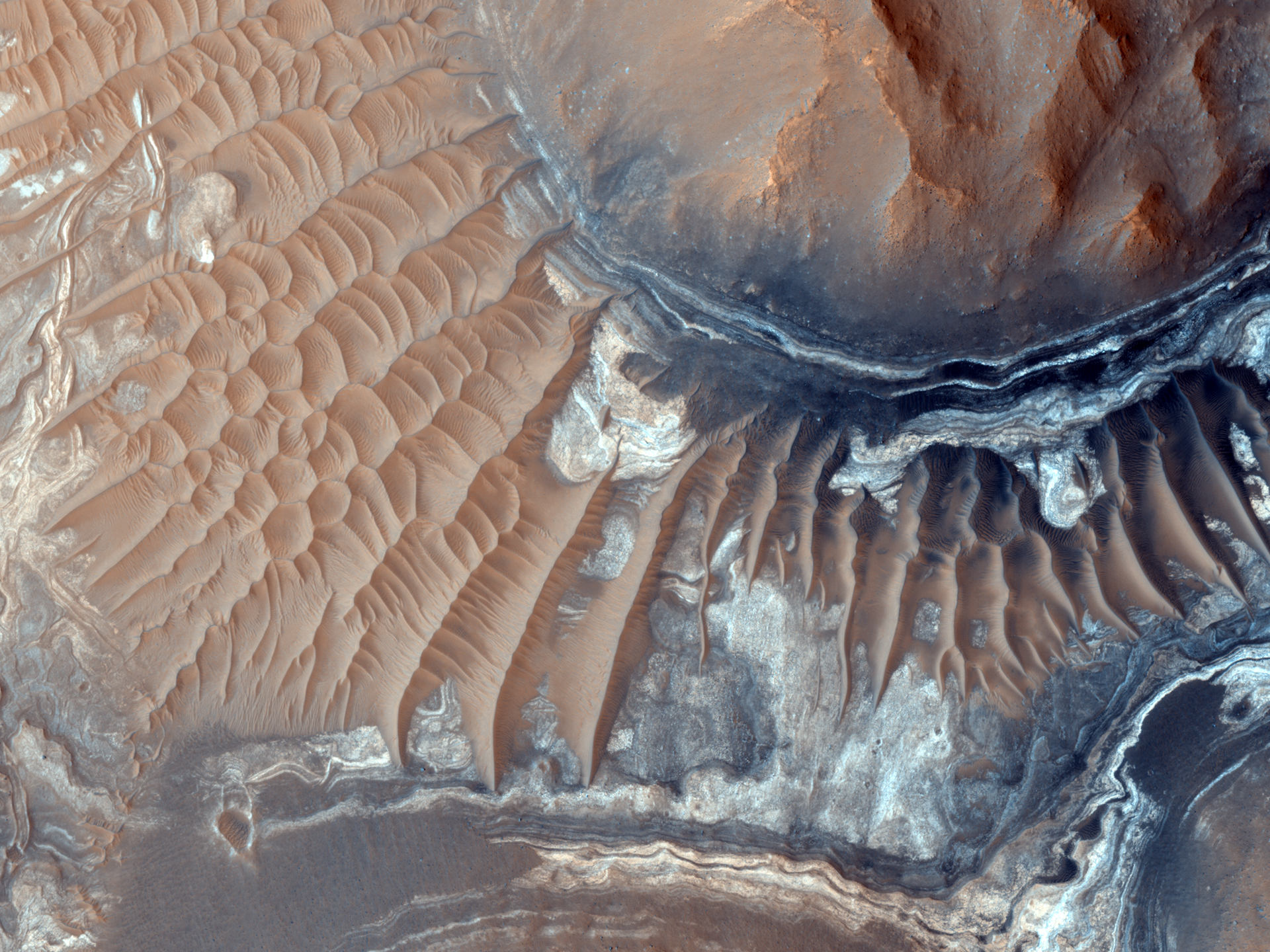
Below is an image of the floor of a 600-mile long canyon called Ius Chasma, which is part of the Valles Marineris, the largest known canyon system in the solar system. The dark rock is an old lava flow, and the lighter areas are megaripples.
Both images were taken by the High Resolution Imaging Science Experiment (HiRISE) camera on the Mars Reconnaissance Orbiter.
Images: NASA/JPL/University of Arizona

These strangely shaped dunes are known as barchan dunes and are common on both Earth and Mars. The form where winds blow mostly in one direction. In the area shown above, the winds were blowing from the top right to the bottom left of the image. Sand is blown up the gentle slopes and falls down the steep lee side of the dunes.
This image was taken by the High Resolution Imaging Science Experiment (HiRISE) camera on the Mars Reconnaissance Orbiter in August 2009.
Image: NASA/JPL/University of Arizona
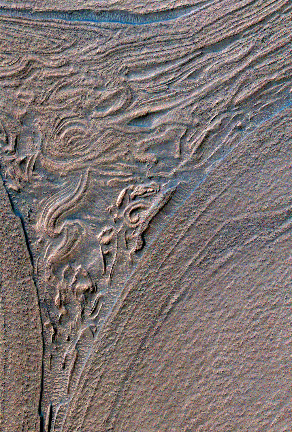
 This image is of the floor of Antoniadi Crater. The dark branchlike areas may be the remains of channels that carried spring water and were filled with material that hardened. Subsequently they dried up and wind eroded the ground around the channels over millions, maybe even billions, of years, leaving the more resistant channel rocks as ridges.
Thie image covers around .6 miles across and was taken in March 2009 by the High Resolution Imaging Science Experiment (HiRISE) camera on NASA's Mars Reconnaissance Orbiter.
Image: NASA/JPL/University of Arizona
 These dunes on a crater floor have a frost of carbon dioxide ice. In the spring, the ice melts directly into vapor. The dark streaks in this image may mark places where the gas has escaped. This image was taken by by the High Resolution Imaging Science Experiment (HiRISE) camera on NASA's Mars Reconnaissance Orbiter on Jan. 1, 2010.
Image: NASA/JPL/University of Arizona
 This image is from the floor of the Hellas Basin, a 1,400-mile wide impact crater. The landforms look almost as if they flowed like a viscous material. This image was taken by the High Resolution Imaging Science Experiment (HiRISE) camera on NASA's Mars Reconnaissance Orbiter on Dec. 26, 2009.
Image: NASA/JPL/University of Arizona
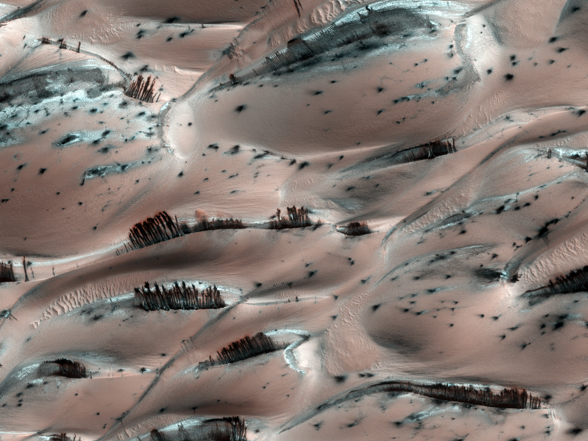 This image looks remarkably like groves of trees growing among Martian dunes. But, the trees are an optical illusion. They are actually dark streaks of sediment on the downwind side of the dunes. They were created by escaping gas from the evaporating carbon dioxide ice below. The bottom of the ice melts into vapor and moves toward holes in the ice, carrying dark sediment along with it that is then deposited when the gas escapes.
This image was taken by the High Resolution Imaging Science Experiment (HiRISE) camera on NASA's Mars Reconnaissance Orbiter in Aprl 2008.
Image: NASA/JPL/University of Arizona
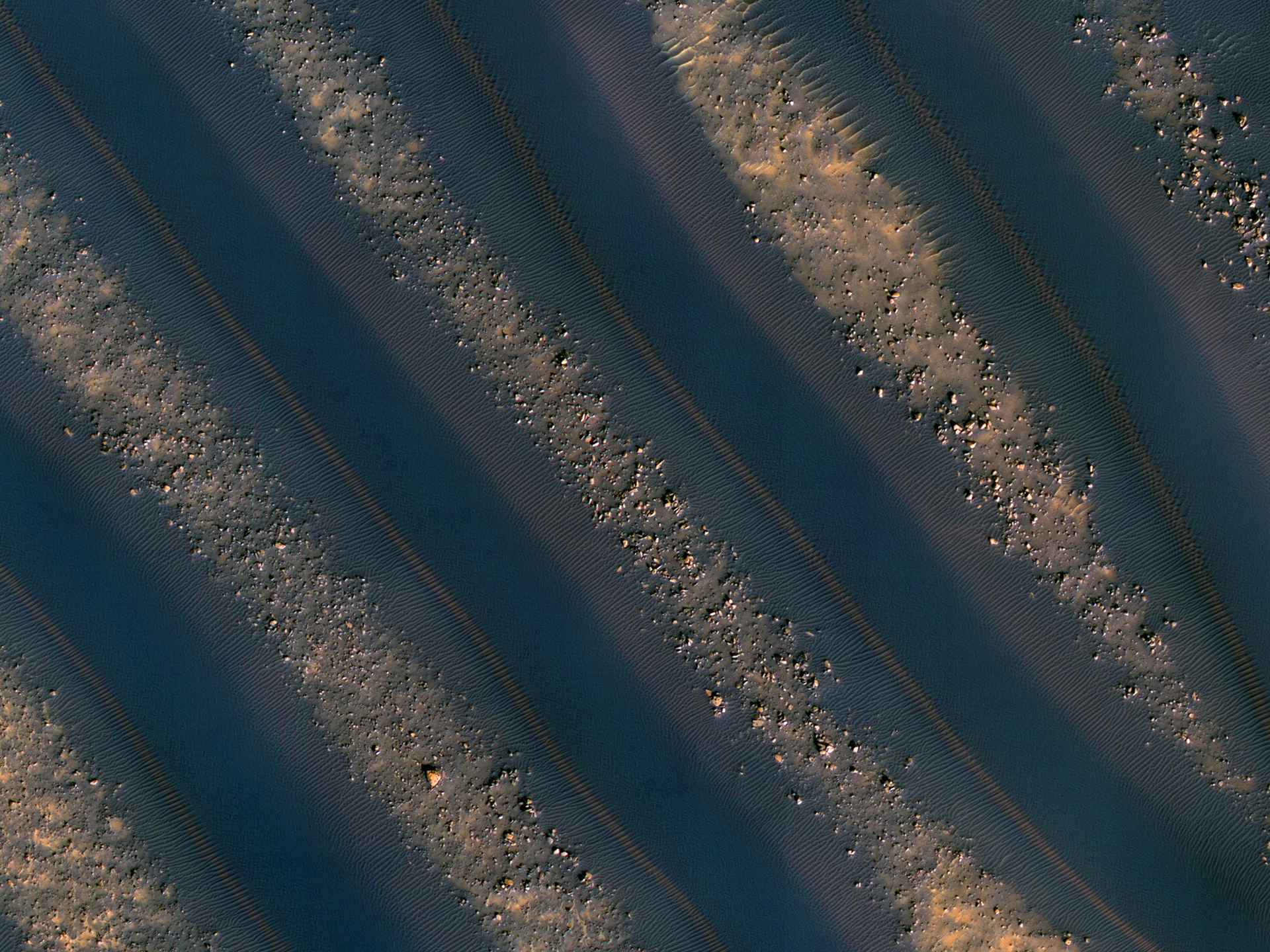 The stripes in this image are linear dunes on the floor of a crater in the Noachis Terra region of Mars. The dark areas are the dunes, and the lighter boulder-strewn lines are between the dunes. This image was taken by the High Resolution Imaging Science Experiment (HiRISE) camera on NASA's Mars Reconnaissance Orbiter on Dec. 28, 2009.
Image: NASA/JPL-Caltech/University of Arizona
See Also:


