
The continental slope in the northern Gulf of Mexico has a very distinct appearance. Note the pock-marked nature in the water depths colored red in this bathymetric image below. The coastal area at the northern end of the image is the Mississippi delta of Louisiana.
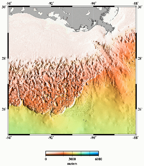
The transition from the pock-marked slope to the smoother and lower-gradient abyssal plain (yellowish colors in image above) is a rather abrupt escarpment with nearly 1,000 m of relief.
Here's another image of the GoM continental slope from a great Geology paper from over 10 years ago now by Pratson and Haxby (link to paper here). This is a perspective view looking towards the east. The black area in the upper left is the continental shelf.
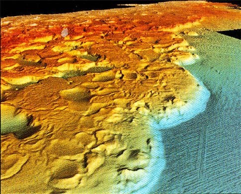
The escarpment I pointed out above is clearly visible in this perspective image. Note the arcuate shape of the trend of this escarpment (called the Sigsbee Escarpment). If it reminds you of a thrust-front, that's because it is!
The morphology of the GoM continental slope is dominated by salt tectonics. Jurassic evaporites have evacuated causing some areas to sink (the pocks, or "mini-basins"). That evacuation is balanced by salt diapirsm in other areas. Overall, the entire slope is affected by gravity and slowly moving towards the deeper part of the basin. The Sigsbee escarpment is the compressional front of that large-scale movement. In detail, each mini-basin is extraordinarily complex showing fascinating relationships between turbidite sedimentation and salt movement. A feedback is set up such that turbidites are deposited in the lowest parts (that's what they do), which causes more underlying salt to evacuate, which in turn makes the basin subside, which maintains that spot being the lowest. Some mini-basins have 20,000 feet of Quaternary sediment in them!
There's tons of information out there regarding the Gulf of Mexico. If you're interested in more, you won't have much trouble finding cool stuff.
Check out this page (a professor at Colorado School of Mines) for more about salt tectonics, in general.
Top image from here.
See all Sea-Floor Sunday posts here.
~~~~~~~~~~~~~~~~~~~~~~~~~~~~~~~~~~~~~~~~~~~~~~~~~~~~~~~~~~~~~


